Hurricane Hunters: Into the Eye of the Storm
Data gathered by special aircraft crucial in hurricane, tropical storm forecasts
By Evan Dougherty
Published September 14, 2020
Read Time: 5 mins
Generally speaking, it’s never a good idea to intentionally fly directly into the middle of a severe storm—especially a hurricane.
Unless, of course, you’re a Hurricane Hunter for the National Oceanic Atmospheric Administration (NOAA). Flying into the eye of a storm is what they do.
“It is hazardous, but it isn’t unconstrained danger,” said Jonathan Shannon, a spokesman for NOAA. “We plan ahead and have risk management procedures in place to make it as safe as possible.”
NOAA, headquartered in Silver Spring, Maryland, focuses on understanding and predicting changes in weather and climate for oceans and coastlines, sharing reliable data with the public and experts. In addition, NOAA manages conservation of marine ecosystems and resources.
Flying specialized aircraft, the Hurricane Hunters support the National Hurricane Center (NHC), a division of NOAA’s National Weather Service, which oversees forecasts of all tropical cyclones in the Atlantic Ocean, Gulf of Mexico and eastern Pacific Ocean.
Flying weather stations
The flying missions are paramount in gathering data for quicker, more accurate hurricane forecasts by experts, allowing for better storm preparation.
“We’re able to increase both the [storm’s] track forecast and accuracy,” Shannon said. “We have been able to narrow that cone of uncertainty and help the NHC improve forecast track accuracy from three days out to five. That builds more time for people to prepare and do what they need to do for their families.”
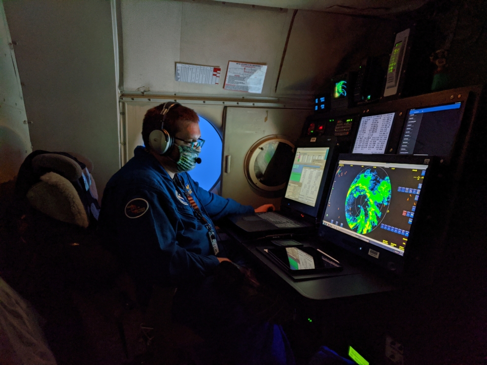
NOAA Flight Director James Carpenter at his station aboard NOAA Lockheed WP-3D Orion N43RF during a flight into Hurricane Hanna. (Image courtesy of NOAA)
Normally, the hurricane center uses a combination of ground-based radar and satellite imagery to collect data on the structure and intensity of cyclones: rotating, organized systems of clouds and thunderstorms that originate over tropical or subtropical waters. (A cyclone can be designated a hurricane or a typhoon depending on where it forms.)
These methods help create models that predict where a cyclone will track and how much it will strengthen or weaken.
A key weakness with satellites, however, is that they are unable to monitor conditions at lower altitudes, leaving gaps in data. That’s where the Hurricane Hunters come in.
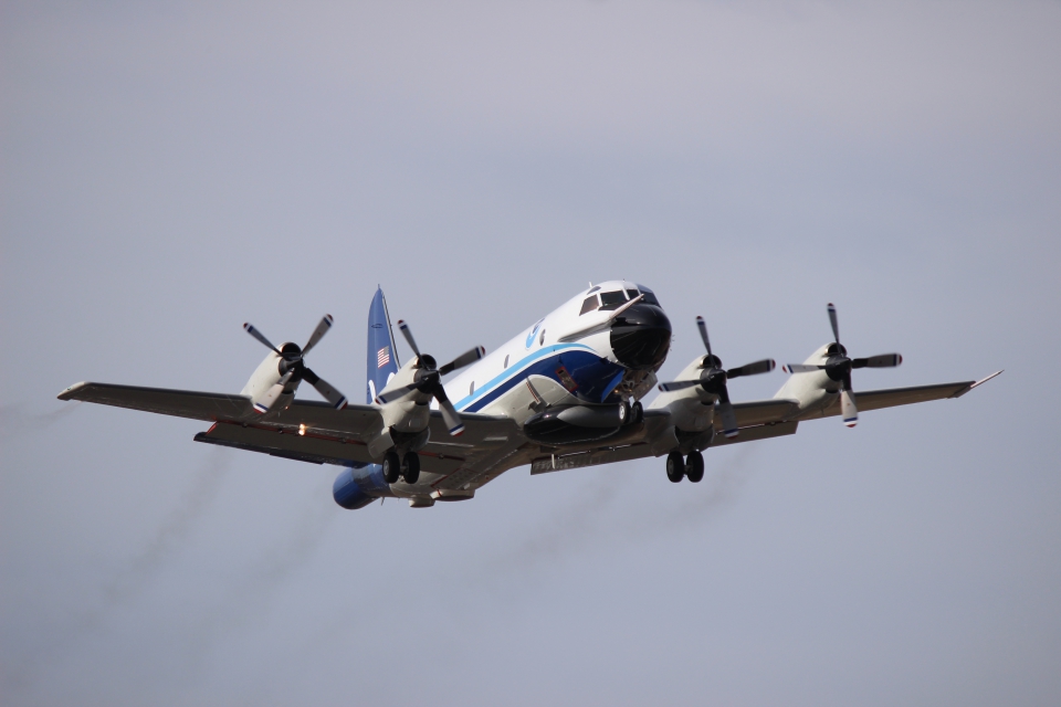
NOAA’s WP-3D Orion aircraft are fitted with doppler radar systems located on the tail, as well as a high power lower fuselage and nose radar. (Image courtesy of NOAA)
The planes fly near or into the storms and collect vital information that helps meteorologists improve their hurricane forecasts by as much as 30 percent.
NOAA operates two WP-3D Orions, which has an airframe similar to the Navy’s P-3 maritime patrol plane. These turboprop aircraft used by NOAA are modified with an expansive array of scientific instrumentation that provide an MRI-like picture of a hurricane’s structure.
The aircraft also have the ability to deploy dropsondes—devices dropped from a tube leading outside the aircraft that fall into the sea, transmitting data on storm conditions, including temperature, air pressure, humidity and windspeed.
‘Highly trained and focused’
Both Hurricane Hunter aircraft operate from Lakeland Linder International Airport in Polk County, Florida.
NOAA is not part of the military, but some of its flight crews come from inter-service transfers from military branches like the U.S. Navy. Many have degrees in science, technology, engineering and math. The rest of the aircrew are NOAA civilian employees.
“Our crews are highly trained and focused, and we have meteorologists on board who help guide them safely to the storm while also coordinating with researchers on the ground,” explained Shannon. “It’s a big team effort.”

On most Hurricane Hunter flights, there is a team of approximately 4-6 scientists on board, in addition to the flight crew. (Image courtesy of NOAA)
A standard flight crew on NOAA surveillance missions consists of three pilots, a navigator and two flight engineers. A flight director, or in-flight meteorologist, on board monitors radar systems and helps guide the crew away from the most dangerous areas of a storm. Electronic, radio and avionics specialists also accompany each flight.
Numbers vary, but most flights also carry a team of approximately 4-6 scientists, each able to monitor sensors and other equipment while conducting their research.
NOAA also operates a Gulfstream IV business jet modified with scientific equipment. The aircraft supplements hurricane surveillance by its ability to fly at higher altitudes, faster and farther than the WP-3D, to sample the atmosphere around, in front of and above the storm.
“[We] take this very seriously,” Shannon added. “It’s not something you can be complacent about.”
Air Force missions
The U.S. Air Force Reserve also gets in the act, supporting hurricane research for the NHC with a fleet of WC-130J Hercules planes.
A modified variant of the C-130 tactical transport, the WC-130J is customized to deploy dropsondes and other expendables, similar to aircraft flown by NOAA.
Ten of these aircraft fly out of the 53rd Weather Reconnaissance Squadron at Keesler Air Force Base in Biloxi, Mississippi. The squadron is part of the Air Force Reserve Command.
The 53rd operates weather surveillance missions year-round like NOAA, collecting important storm data for the NHC.
“Mother Nature doesn’t operate on a calendar,” Col. Jeffrey A. Van Dootingh, commander of the 403rd Wing, said in a statement at the start of this year’s hurricane season. “The 53rd is prepared, ready and able.”
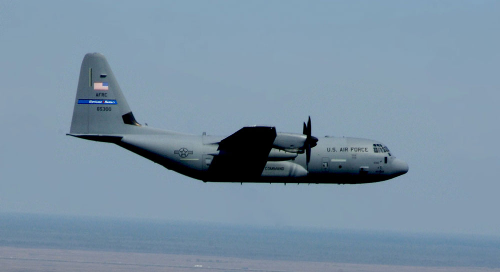
The Air Force Reserve supports hurricane data collection for the NHC, operating a fleet of WC-130J Hercules planes. (Image courtesy of 53rd Weather Reconnaissance Squadron)
The WC-130J is flown by a pilot and co-pilot who are supported by a navigator monitoring severe weather on radar. A weather reconnaissance officer oversees atmospheric data collected by the plane’s sensors while a weather reconnaissance loadmaster monitors onboard equipment and deployment of dropsondes.
The WC-130J flies two kinds of missions. During an investigative mission, the crew observe and confirm the cyclonic rotation of a potential tropical storm. The aircraft flies at lower altitudes, usually between 500 and 1,500 feet above sea level, and collects data on the speed and direction of winds.
Fix missions involve flying towards the eye of the storm and providing that center position to update forecast models. For these missions, the aircraft flies at 10,000 feet in an orbit-like pattern.
An active season
Last month, NOAA flew a WP-3D into the eye of Hurricane Laura, which peaked as a Category 4 storm with winds as high as 150 miles per hour. The crew battled turbulence throughout the flight caused by the updrafts and downdrafts within the storm.
The 53rd conducted seven surveillance missions into Hurricane Laura from Joint Base Charleston, South Carolina. The squadron temporarily staged operations from Charleston after its home base at Keesler had been evacuated because of the incoming storm.
“Whether the season is considered ‘active’ or not, it just takes one storm near you to make it a bad season for you,” Shannon said. “Plan ahead and prepare before the storm hits using the great information from NHC and your local weather forecast office. It’s why we fly.”
Watch
This Next

Read
This Next