Hurricane Hunters: Into the Eye of the Storm
Data gathered by special aircraft crucial in hurricane, tropical storm forecasts
By Evan Dougherty
Published September 14, 2020
Read Time: 6 mins

Editor’s note: This story was updated on Oct. 14, 2024 to reflect recent operations conducted by NOAA and the U.S. Air Force during Hurricanes Helene and Milton.
Generally speaking, it’s never a good idea to intentionally fly directly into the middle of a severe storm—especially a hurricane.
Unless, of course, you’re a Hurricane Hunter for the National Oceanic Atmospheric Administration (NOAA). Flying into the eye of a storm is what they do.
“It is hazardous, but it isn’t unconstrained danger,” said Jonathan Shannon, a spokesman for NOAA. “We plan ahead and have risk management procedures in place to make it as safe as possible.”
NOAA, headquartered in Silver Spring, Maryland, focuses on understanding and predicting changes in weather and climate for oceans and coastlines, sharing reliable data with the public and experts. In addition, NOAA manages conservation of marine ecosystems and resources.
Flying specialized aircraft, the Hurricane Hunters support the National Hurricane Center (NHC), a division of NOAA’s National Weather Service, which oversees forecasts of all tropical cyclones in the Atlantic Ocean, Gulf of Mexico and eastern Pacific Ocean.
Flying weather stations
The flying missions are paramount in gathering data for quicker, more accurate hurricane forecasts by experts, allowing for better storm preparation.
“We’re able to increase both the [storm’s] track forecast and accuracy,” Shannon said. “We have been able to narrow that cone of uncertainty and help the NHC improve forecast track accuracy from three days out to five. That builds more time for people to prepare and do what they need to do for their families.”
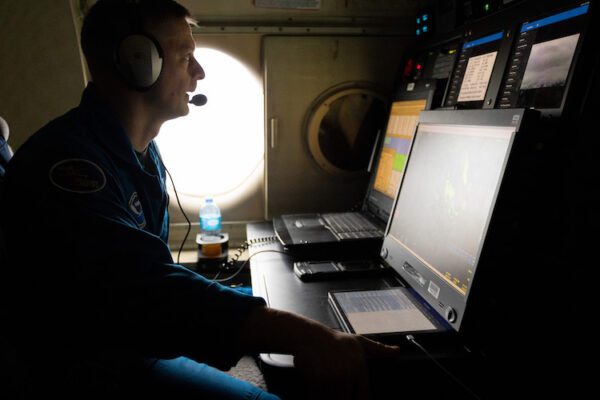
Flight Director Quinn Kalen at his work station onboard NOAA WP-3D Orion N43RF during a flight to Hurricane Lee on Sept. 8, 2023. (Photo by Lt. Cmdr. Andrew Utama/NOAA)
Normally, the hurricane center uses a combination of ground-based radar and satellite imagery to collect data on the structure and intensity of cyclones: rotating, organized systems of clouds and thunderstorms that originate over tropical or subtropical waters. (A cyclone can be designated a hurricane or a typhoon depending on where it forms.)
These methods help create models that predict where a cyclone will track and how much it will strengthen or weaken.
A key weakness with satellites, however, is that they are unable to monitor conditions at lower altitudes, leaving gaps in data. That’s where the Hurricane Hunters come in.
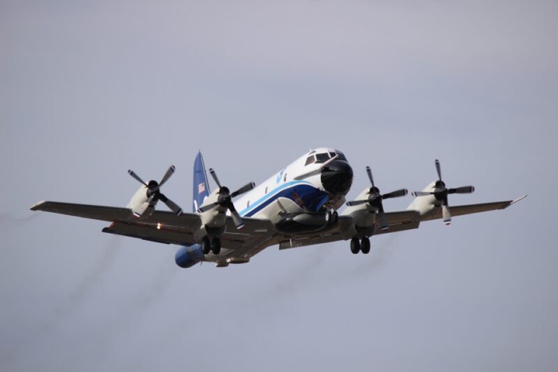
NOAA’s WP-3D Orion aircraft are fitted with doppler radar systems located on the tail, as well as a high power lower fuselage and nose radar. (Image courtesy of NOAA)
The planes fly near or into the storms and collect vital information that helps meteorologists improve their hurricane forecasts by as much as 30 percent.
NOAA operates two WP-3D Orions, which has an airframe similar to the Navy’s P-3 maritime patrol plane. These turboprop aircraft used by NOAA are modified with an expansive array of scientific instrumentation that provide an MRI-like picture of a hurricane’s structure.
The aircraft also have the ability to deploy dropsondes—devices dropped from a tube leading outside the aircraft that fall into the sea, transmitting data on storm conditions, including temperature, air pressure, humidity and windspeed.
‘Highly trained and focused’
Both Hurricane Hunter aircraft operate from Lakeland Linder International Airport in Polk County, Florida.
NOAA is not part of the military, but some of its flight crews come from inter-service transfers from military branches like the U.S. Navy. Many have degrees in science, technology, engineering and math. The rest of the aircrew are NOAA civilian employees.
“Our crews are highly trained and focused, and we have meteorologists on board who help guide them safely to the storm while also coordinating with researchers on the ground,” explained Shannon. “It’s a big team effort.”
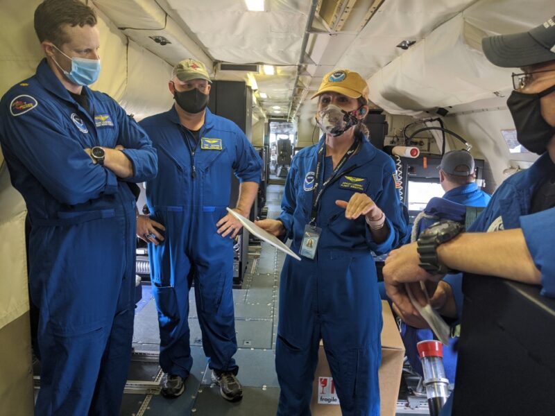
On most Hurricane Hunter flights, there is a team of approximately 4-6 scientists on board, in addition to the flight crew. (Courtesy of NOAA)
A standard flight crew on NOAA surveillance missions consists of three pilots, a navigator and two flight engineers. A flight director, or in-flight meteorologist, on board monitors radar systems and helps guide the crew away from the most dangerous areas of a storm. Electronic, radio and avionics specialists also accompany each flight.
Numbers vary, but most flights also carry a team of approximately 4-6 scientists, each able to monitor sensors and other equipment while conducting their research.
NOAA also operates a Gulfstream IV business jet modified with scientific equipment. The aircraft supplements hurricane surveillance by its ability to fly at higher altitudes, faster and farther than the WP-3D, to sample the atmosphere around, in front of and above the storm.
“[We] take this very seriously,” Shannon added. “It’s not something you can be complacent about.”
Air Force missions
The U.S. Air Force Reserve also gets in the act, supporting hurricane research for the NHC with a fleet of WC-130J Hercules planes.
A modified variant of the C-130 tactical transport, the WC-130J is customized to deploy dropsondes and other expendables, similar to aircraft flown by NOAA.
Ten of these aircraft fly out of the 53rd Weather Reconnaissance Squadron at Keesler Air Force Base in Biloxi, Mississippi. The squadron is part of the Air Force Reserve Command.
The 53rd operates weather surveillance missions year-round like NOAA, collecting important storm data for the NHC.
“We provide a lot of effort to collect this data for NHC so they can provide accurate forecasts to give the public the most advanced warnings so they can prepare and get their families to safety as appropriate,” said Lt. Col. Brad Boudreaux, 53rd Weather Reconnaissance Squadron pilot. “It’s best for communities to prepare in advance for extreme weather, water and climate events.”
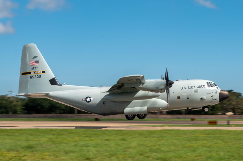
A WC-130J assigned to the 53rd Weather Reconnaissance Squadron approaches the runway to land at Keesler Air Force Base, Miss., on Sept. 12, 2024. (Photo by Tech. Sgt. Kristen Pittman/403rd Wing)
The WC-130J is flown by a pilot and co-pilot who are supported by a navigator monitoring severe weather on radar. A weather reconnaissance officer oversees atmospheric data collected by the plane’s sensors while a weather reconnaissance loadmaster monitors onboard equipment and deployment of dropsondes.
The WC-130J flies two kinds of missions. During an investigative mission, the crew observe and confirm the cyclonic rotation of a potential tropical storm. The aircraft flies at lower altitudes, usually between 500 and 1,500 feet above sea level, and collects data on the speed and direction of winds.
Fix missions involve flying towards the eye of the storm and providing that center position to update forecast models. For these missions, the aircraft flies at 10,000 feet in an orbit-like pattern.
An active season
Earlier this month, NOAA deployed a WP-3D to survey Hurricane Milton off the Gulf Coast of Florida, which peaked as a Category 5 storm with winds of up to 180 miles per hour, making it one of the largest hurricanes ever recorded. Data obtained by NOAA’s flight operations were vital for forecasting Milton and hurricane research.
Bumpy ride into Hurricane #Milton on @NOAA WP-3D Orion #NOAA43 “Miss Piggy” to collect data to help improve the forecast and support hurricane research.
Visit https://t.co/3phpgKNx0q for the latest forecasts and advisories
Visit https://t.co/UoRa967zK0 for information that you… pic.twitter.com/ezmXu2Zqta— NOAA Aircraft Operations Center (@NOAA_HurrHunter) October 8, 2024
NOAA also conducted flights into the eye of Hurricane Helene, which peaked as a Category 4 storm, in September. Video footage from NOAA showed flight crews battling turbulence caused by updrafts and downdrafts of the storm while flight tracking site FlightAware showed the WP-3D made several orbits in the eye collecting storm data.
Additionally, the 53rd conducted numerous surveillance missions of Helene and Milton. The unit flew nine missions through Helene Sept. 23-26 and eight missions into Milton through Oct. 10.
“Whether the season is considered ‘active’ or not, it just takes one storm near you to make it a bad season for you,” Shannon said. “Plan ahead and prepare before the storm hits using the great information from NHC and your local weather forecast office. It’s why we fly.”